
Purpose and goals of the Eurobodalla Koalas Project.
Our volunteer project exists to revive the Eurobodalla’s wild koala population, through:
- assistance to landholders engaged in rehabilitation
- citizen-science
- advocacy
The project also exists to help others exploit the Eurobodalla’s koala story for commercial and cultural reasons.
The project relies upon community interactions and the energy of contributors rather than a formal structure.
We enjoy in-kind sponsorship from The Coastwatchers Association Inc (the Eurobodalla’s not-for-profit environment group) and ad hoc assistance from government and other non-government entities.
Current priorities are:
- promotion and implementation of the Eurobodalla Koala Recovery Strategy
- public awareness and education campaign
- desktop and field-based research
Examples of things we try to do, are:
- publicise our scientific work
- contribute to the Eurobodalla’s post-fire and post-COVID-19 recovery by promoting re-imagined, nature-led economic initiatives
- engage directly with landholders, agencies and businesses
- seek venture capital for koala-oriented eco-businesses
- explain potential business models, and invite businesses and other potential partners to come up with their own
Where are we now?
Currently the Eurobodalla Koala Recovery Strategy is in a monitoring phase, where we wait to discover whether the current decade produces a natural revival, while at the same time taking any available opportunity to intervene. Please follow this link to view koala in the Eurobodalla that have been identified by acoustic meters and drone surveys. We follow up any rare sighting or scat reports and collaborate with private property owners and public land managers such as Forestry Corporation NSW. This includes our ongoing koala habitat plot surveys, and information sharing.
WWF-GER Project
Thanks to funds provided by the Coastwatchers Great Eastern Ranges/Worldwide Fund for Nature-Australia partnership, we have been able to support:
- Revegetation of connectivity patches on 8 private properties
- A community wildlife questionnaire trial
- iNaturalist training for multiple community groups
- Weed control on Deua River koala habitat
- Virtual fencing for roadside wildlife protection
- Special projects for species which share koala habitat, eg Spotted-tailed Quolls and Greater Gliders
Spatial Analysis
EKP continues to research local koala habitat suitability, especially potential home ranges and breeding corridors, for the purpose of koala population revival.
We try to publicise the need for a widespread, viable metapopulation across Shire borders, to underpin the breeding patterns for sustaining any local small resident groups.
One way to target critical habitat patches is through Geographic Information Systems (GIS) modelling and spatial analysis.
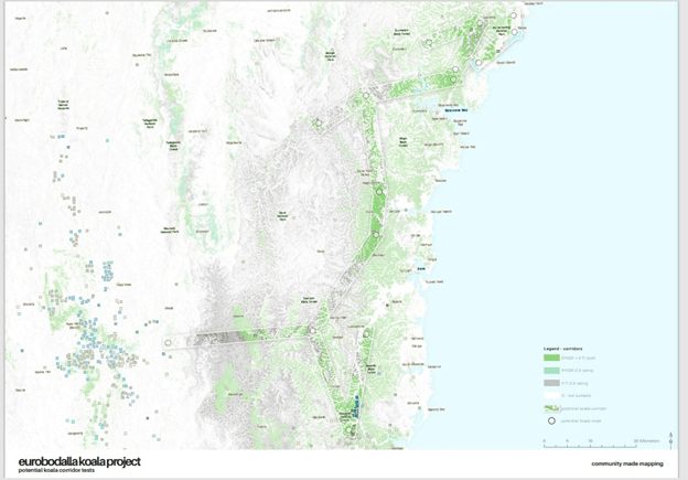
Comparing the following maps gives an indication of how viable a particular habitat area is in terms of vegetation type etc, how a hypothetical home range or corridor might match koala records, and where best to locate any revegetation plantings.
The first map, prepared by our volunteer, overlays BioNet Koala Habitat Suitability and the BioNet Koala Tree Index on the potential breeding corridors EKP hypothesizes, based on our 12 years of research documented elsewhere on this website. The map tends to confirm the conclusions in our Pilot Study (and those after it) about good Eurobodalla habitat connecting critical places from north to south, but potential breeding between the Eurobodalla and the Cooma region populations still looks challenging.
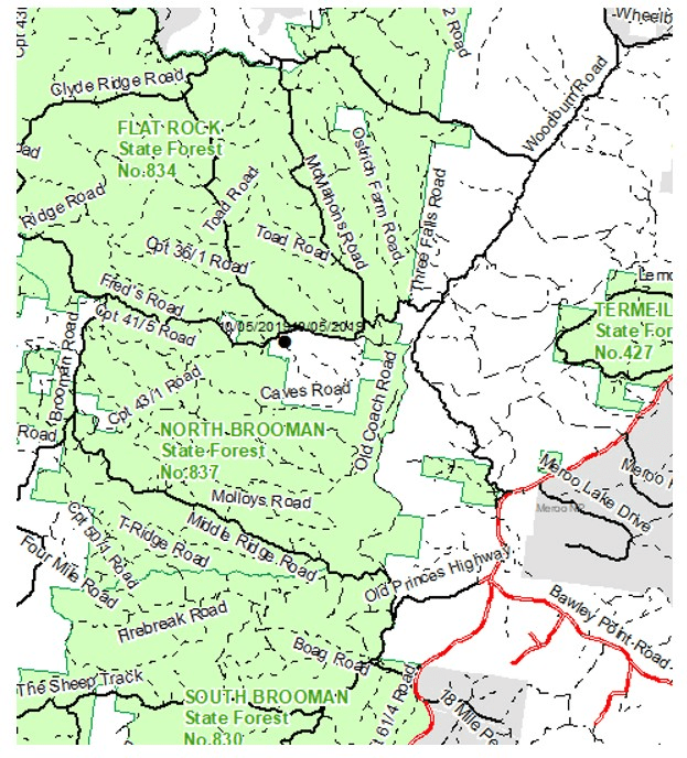
The next three maps passed to us by the FCNSW ecologist, show recent BioNet koala records (circa 2020), one in North Brooman State Forest (pre-fire), some between Tinpot and Dignam’s Creek Road, and many in the Murrah/Mumbulla area (but sadly none in Bermagui, where we had postulated a breeding corridor from Bodalla State Forest).
The final map shows a very localized study (Bergalia/Bingie/Congo/Meringo) where the GER spatial analyst has used a very sophisticated technique to display “preferred wildlife corridors”.
The North Brooman record reinforces the 2019 fire report and the 2020 post-fire reports at East Lynne. Combining these with an unconfirmed 2022 Cockwhy report and the old records from 2000 and 2009, EKP hopes there might still be a small resident group in the East Lynne/Cockwhy/Murramarang area.
The healthy looking 2020 Tinpot/Dignam’s Creek records reinforce the NSW OEH findings circa 2007, where it was suggested a critically endangered group of 5 to 15 animals was resident at Sam’s Ridge, Kooraban National Park, probably connected to the Bermagui population. The good news is they’re still there; the bad news is there are no new records for Bermagui State Forest.
Further south, the NSW Koala Strategy prioritises the Bega/Eden region, where koalas are more numerous than in the Eurobodalla.
The GER map replicates the EKP hypothesis that an important corridor exists between Eurobodalla National Park and Moruya State Forest, but it requires further rehabilitation and a strategically placed wildlife crossing over the Princes Highway at Bergalia/Coila.
Map 1 – KHSM and KTI BioNet models overlaid on EKP hypothesized corridors
Map 2 – North Brooman record
Map 3 – Kooraban National Park area records

Map 4 – Murrah/Mumbulla

Map 5 – GER preferred wildlife corridors around Bergalia

